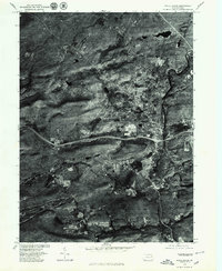
1976 Map of White Haven
USGS Topo · Published 1979About this map
White Haven and its surrounding mountain terrain are captured in this 1976 orthophoto, which uses aerial photography to show the exact ground cover of the era. The image highlights the intersection of transportation and topography, where the Lehigh River carves a deep path through the landscape near the community of Middleburg. Unlike standard topographic maps, this aerial perspective reveals the precise density of forest cover across Green Mountain and the distinct layout of residential developments near Penn Lake. Local settlements like Sandy Run and Pond Creek appear as concentrated clearings within the timbered hills. For the local historian, the imagery provides a clear view of the mid-1970s infrastructure, including the highway corridors that cut through the valley, offering a literal picture of the region before further modern expansion.
Find a feature on this map
7 named features on this map. Tap any name to fly to it.
Don’t see what you’re looking for? This feature index may not catch every label — zoom into the map to look around manually.
Map Details
Editions of this 1976 White Haven Map
This is the sole edition of this map. No revisions or reprints were ever made.
Other maps of this area

1889 · Hazleton
USGS Topo · 1:62,500

1891 · Wilkesbarre
USGS Topo · 1:62,500

1891 · Hazleton
USGS Topo · 1:62,500

1893 · Hazleton
USGS Topo · 1:62,500

1894 · Wilkesbarre
USGS Topo · 1:62,500

1922 · Mauch Chunk
USGS Topo · 1:62,500

1922 · Stoddartsville
USGS Topo · 1:62,500

1924 · Stoddartsville
USGS Topo · 1:62,500

1924 · Mauch Chunk
USGS Topo · 1:62,500

1943 · Scranton
USGS Topo · 1:125,000