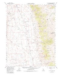
1962 Map of White Mtn. Peak
USGS Topo · Published 1984About this map
The White Mountains dominate this high-altitude landscape, rising dramatically above the Hammil Valley and Chalfant Valley in the early 1960s. At the summit of White Mtn Peak, the White Mountain Research Sta Summit Laboratory (University of California) stands as a remote outpost for high-altitude study. The valley floor reflects a rugged agricultural economy centered around family holdings such as Harris Bros Ranch, Symons Ranch, and Cashbaugh Ranch, all positioned near the essential Aqueduct and flume systems.
Find a feature on this map
59 named features on this map. Tap any name to fly to it.
Don’t see what you’re looking for? This feature index may not catch every label — zoom into the map to look around manually.
Map Details
Editions of this 1962 White Mtn. Peak Map
3 editions found

Other maps of this area

1912 · Mt. Goddard
USGS Topo · 1:125,000

1913 · Bishop
USGS Topo · 1:125,000

1914 · Mt. Morrison
USGS Topo · 1:125,000

1917 · White Mountain
USGS Topo · 1:125,000

1947 · Mariposa
USGS Topo · 1:250,000

1948 · Mariposa
USGS Topo · 1:250,000

1949 · Mt. Tom
USGS Topo · 1:62,500

1949 · Bishop
USGS Topo · 1:62,500

1951 · Mt. Tom
USGS Topo · 1:62,500

1951 · Bishop
USGS Topo · 1:62,500