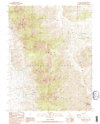
1987 Map of White Mtn. Peak
USGS Topo · Published 1987About this map
White Mtn Peak White Mountain Research Sta Summit Laboratory University of California crowns this high-altitude landscape, marking a center for scientific study in the eastern Sierra. The terrain within the Inyo National Forest is defined by severe elevation changes, rising from the Hill Ranch and Lone Tree Creek in the lowlands to the alpine expanses of Pellisier Flats and peaks such as Mt Hogue. Resource extraction is evident through the Open Pit Mine and the naming of Jeffrey Mine Canyon, while water sources like Cottonwood Canyon Creek and Birch Creek cut through the steep canyons. The map serves as a detailed record of the borderlands between Mono and Inyo counties during the late 1980s.
Find a feature on this map
21 named features on this map. Tap any name to fly to it.
Don’t see what you’re looking for? This feature index may not catch every label — zoom into the map to look around manually.
Map Details
Editions of this 1987 White Mtn. Peak Map
2 editions found
Other maps of this area

1917 · White Mountain
USGS Topo · 1:125,000

1947 · Mariposa
USGS Topo · 1:250,000

1948 · Mariposa
USGS Topo · 1:250,000

1957 · Mariposa
USGS Topo · 1:250,000

1962 · Benton
USGS Topo · 1:62,500

1962 · Mt. Barcroft
USGS Topo · 1:62,500

1962 · White Mtn. Peak
USGS Topo · 1:62,500

1963 · Mariposa
USGS Topo · 1:250,000

1963 · Davis Mountain
USGS Topo · 1:62,500
1987 · Juniper Mtn
USGS Topo · 1:24,000