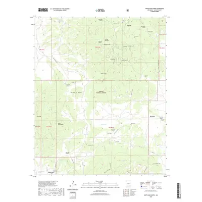
2020 Map of White Oaks North
USGS Topo · Published 2020About this map
Jicarilla and the northern outskirts of White Oaks define this high-altitude landscape within the Lincoln National Forest. The map documents a rugged terrain shaped by the Jicarilla Mountains, where peaks like Ancho Peak and Monument Peak rise above a complex network of canyons and gulches. Evidence of early mining-era settlement remains visible through the presence of the Jicarilla Cem and Reventon Cem, which serve as vital markers for local genealogy. The importance of water management in this arid environment is highlighted by numerous artificial catchments, including Hoecradle Tank, Ancho Tank, and Dillard Tank. Transportation through these high basins is facilitated by established routes such as Coyote Canyon Road and the Barber Springs Trail. Distinctive geological formations, from Castle Garden Mesa to Patos Mtn, overlook smaller settlements like Reventon, providing a clear picture of the historical and geographical layout of this corner of Lincoln County.
Find a feature on this map
56 named features on this map. Tap any name to fly to it.
Don’t see what you’re looking for? This feature index may not catch every label — zoom into the map to look around manually.
Map Details
Editions of this 2020 White Oaks North Map
This is the sole edition of this map. No revisions or reprints were ever made.
Other maps of this area

1934 · Capitan
USGS Topo · 1:48,000

1937 · Capitan
USGS Topo · 1:62,500

1938 · Carrizozo
USGS Topo · 1:48,000

1943 · Carrizozo
USGS Topo · 1:62,500

1950 · Carrizozo
USGS Topo · 1:62,500

1950 · Little Black Peak
USGS Topo · 1:62,500

1955 · Roswell
USGS Topo · 1:250,000

1958 · Roswell
USGS Topo · 1:250,000

1962 · Roswell
USGS Topo · 1:250,000

1973 · Ancho
USGS Topo · 1:24,000