
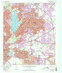
1958 Map of White Rock Lake
USGS Topo · Published 1974About this map
White Rock Lake serves as the focal point of this Eastern Dallas landscape, which is shown during a period of rapid suburban expansion. The transition from established neighborhoods to new developments is clearly visible in the purple revisions, particularly around Reinhardt and the eastern edge toward Mesquite. This era is defined by the convergence of major transportation corridors, including the Southern Pacific and Texas and Pacific railroads, which share the terrain with emerging thoroughfares like World War II Veterans Memorial Highway.
Find a feature on this map
139 named features on this map. Tap any name to fly to it.
Don’t see what you’re looking for? This feature index may not catch every label — zoom into the map to look around manually.
Map Details
Editions of this 1958 White Rock Lake Map
2 editions found
Other maps of this area

1891 · Dallas
USGS Topo · 1:125,000

1893 · Dallas
USGS Topo · 1:125,000

1931 · Carrollton
USGS Topo · 1:62,500

1954 · Dallas
USGS Topo · 1:250,000

1957 · White Rock Lake
USGS Topo · 1:24,000

1958 · Dallas
USGS Topo · 1:250,000

1958 · Hutchins
USGS Topo · 1:24,000

1958 · Oak Cliff
USGS Topo · 1:24,000

1958 · Dallas
USGS Topo · 1:24,000

1959 · Mesquite
USGS Topo · 1:24,000