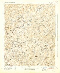
1940 Map of White Rock
USGS Topo · Published 1940About this map
Shelton Laurel Creek and Big Laurel Creek carve through the high elevations of Madison County in this 1939 field study. The landscape is defined by family-named landmarks and small, isolated mountain communities such as White Rock, Cutshalltown, and Belva. Settlement patterns follow the creek beds and gaps, with social life anchored by country churches like Middle Laurel Ch and Piney Grove Ch.
Find a feature on this map
121 named features on this map. Tap any name to fly to it.
Don’t see what you’re looking for? This feature index may not catch every label — zoom into the map to look around manually.
Map Details
Editions of this 1940 White Rock Map
2 editions found
Other maps of this area

1892 · Greeneville
USGS Topo · 1:125,000

1894 · Asheville
USGS Topo · 1:125,000

1896 · Greeneville
USGS Topo · 1:125,000

1901 · Asheville
USGS Topo · 1:125,000

1904 · Greeneville
USGS Topo · 1:125,000

1935 · Hot Springs
USGS Topo · 1:24,000

1935 · Spring Creek
USGS Topo · 1:24,000

1936 · Marshall
USGS Topo · 1:24,000

1936 · Greystone
USGS Topo · 1:24,000

1936 · Sams Gap
USGS Topo · 1:24,000