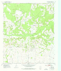
1950 Map of White Rock
USGS Topo · Published 1978About this map
Reeds Settlement and Madras are central landmarks in this rural portrait of Red River County, recorded during the mid-twentieth century. The landscape is defined by its social infrastructure of small community schools and churches, including Madras Sch, Haywood Sch, and Shiloh Ch, which anchored the local farmstead economy. These small rural hubs are connected by a network of local roads such as Schalline, navigating a terrain deeply dissected by a dense drainage system.
Find a feature on this map
30 named features on this map. Tap any name to fly to it.
Don’t see what you’re looking for? This feature index may not catch every label — zoom into the map to look around manually.
Map Details
Editions of this 1950 White Rock Map
2 editions found
Other maps of this area

1950 · Acworth
USGS Topo · 1:24,000

1950 · White Rock
USGS Topo · 1:24,000

1950 · Annona
USGS Topo · 1:24,000

1951 · Idabel SE
USGS Topo · 1:24,000

1951 · English
USGS Topo · 1:24,000

1951 · Annona
USGS Topo · 1:24,000

1951 · White Rock
USGS Topo · 1:24,000

1951 · Acworth
USGS Topo · 1:24,000

1951 · Avery
USGS Topo · 1:24,000

1951 · Negley
USGS Topo · 1:24,000