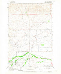
1958 Map of White Swan
USGS Topo · Published 1968About this map
White Swan serves as the primary hub of activity on this Yakima County landscape, defined by a complex network of irrigation and agricultural infrastructure in the late 1950s. The settlement is anchored by a High School, Community Hall, and nearby Rodeo Grounds, reflecting a community built around local assembly and livestock heritage. To the north, the terrain transitions from the irrigated Olney Flat toward the higher elevations of VABM Wiley, while the valley floors are irrigated by the Wapato Main Canal and Highline Canal. Water management is central to the area's identity, with numerous named wells and branches of Medicine Valley feeding into Simcoe Creek. Local transit and ranching operations are visible through features like the Kent Ranch and the Hitchcock Airstrip, alongside family-named routes such as Evans Road and Barkes Road that segment the surrounding farmland.
Find a feature on this map
56 named features on this map. Tap any name to fly to it.
Don’t see what you’re looking for? This feature index may not catch every label — zoom into the map to look around manually.
Map Details
Editions of this 1958 White Swan Map
3 editions found

Other maps of this area

1899 · Ellensburg
USGS Topo · 1:125,000

1901 · Ellensburg
USGS Topo · 1:125,000

1937 · White Swan
USGS Topo · 1:125,000

1950 · Yakima
USGS Topo · 1:250,000

1958 · Toppenish Mtn.
USGS Topo · 1:24,000

1958 · Harrah
USGS Topo · 1:24,000
1958 · Yakima West
USGS Topo · 1:24,000

1958 · Fort Simcoe
USGS Topo · 1:24,000

1958 · Fort Simcoe
USGS Topo · 1:62,500

1958 · Wiley City
USGS Topo · 1:24,000