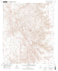
1957 Map of White Tank Mts
USGS Topo · Published 1995About this map
The White Tank Mts dominate this mid-century topographic survey, revealing a landscape defined by high-elevation communications and military utility. Surveyed in 1954 and field-checked in 1957, the map captures a network of technical landmarks including the Microwave Radio Towers VABM 4018, a separate Microwave Radio Tower, and several Beacons. These features, along with VABM Light 3671, emphasize the range's importance for line-of-sight signaling and regional navigation during the early Cold War era.
Find a feature on this map
12 named features on this map. Tap any name to fly to it.
Don’t see what you’re looking for? This feature index may not catch every label — zoom into the map to look around manually.
Map Details
Editions of this 1957 White Tank Mts Map
5 editions found
Other maps of this area

1946 · Avondale
USGS Topo · 1:62,500

1948 · Cashion
USGS Topo · 1:62,500

1954 · Phoenix
USGS Topo · 1:250,000

1957 · Phoenix
USGS Topo · 1:250,000

1957 · White Tank Mts. SE
USGS Topo · 1:24,000

1957 · Valencia
USGS Topo · 1:24,000

1957 · Perryville
USGS Topo · 1:24,000

1957 · White Tank Mts. NE
USGS Topo · 1:24,000

1957 · McMicken Dam
USGS Topo · 1:24,000

1957 · Waddell
USGS Topo · 1:24,000