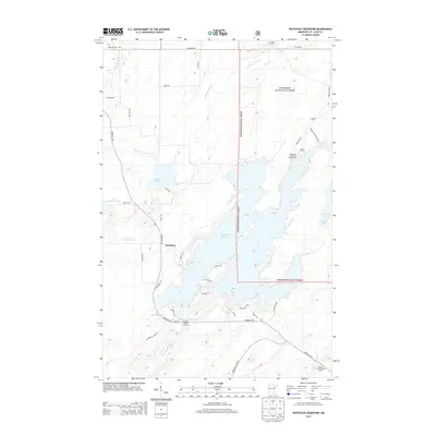
2013 Map of Whiteface Reservoir
USGS Topo · Published 2013About this map
Whiteface Reservoir and its complex of northern waters dominate this landscape within the Superior National Forest in Saint Louis County. The settlement of Markham serves as a local hub, situated near the headwaters of the Paleface River and the shores of Markham Lake. The map reveals a high concentration of water features, including Whiteface Lake, Little Markham Lake, and smaller bodies like Linwood Lake and Wiggle Lake, all interconnected by a network of creeks such as Water Hen Cr and Tynjala Cr. This area reflects a mid-twentieth-century focus on forest management and recreation, evidenced by the Cloquet Valley Lookout Tower and the Whiteface Reservoir Campground. The transportation grid, defined by routes like Vermilion Trl and Whiteface River Rd, provides access to both residential clusters and the expansive timberlands that define this portion of the Arrowhead Region.
Find a feature on this map
43 named features on this map. Tap any name to fly to it.
Don’t see what you’re looking for? This feature index may not catch every label — zoom into the map to look around manually.
Map Details
Editions of this 2013 Whiteface Reservoir Map
This is the sole edition of this map. No revisions or reprints were ever made.
Other maps of this area

1951 · Palo
USGS Topo · 1:24,000

1951 · Makinen
USGS Topo · 1:24,000

1954 · Hibbing
USGS Topo · 1:250,000

1956 · Whiteface
USGS Topo · 1:24,000

1957 · Hibbing
USGS Topo · 1:250,000

1957 · Markham
USGS Topo · 1:62,500

1957 · Comstock Lake
USGS Topo · 1:24,000
1957 · Boulder Lake Reservoir NE
USGS Topo · 1:24,000

1958 · Hibbing
USGS Topo · 1:250,000

1964 · Hibbing
USGS Topo · 1:250,000