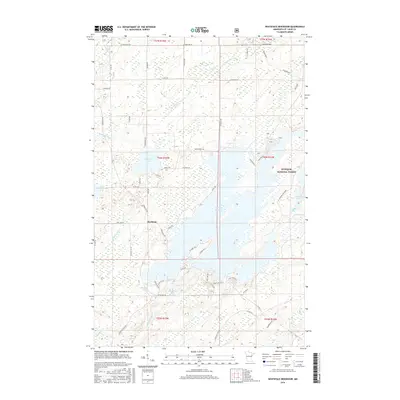
2016 Map of Whiteface Reservoir
USGS Topo · Published 2016About this map
Whiteface Reservoir dominates this landscape in Saint Louis County, serving as a central hydrological feature within the Superior National Forest. The settlement of Markham sits west of the reservoir, connected by a network of local routes such as Vermillion Trl and Aurora Rd. The area is defined by its complex waterway system, including Whiteface Lake, Markham Lake, and the winding Whiteface River. This 2016 survey illustrates the 21st-century configuration of these glacial lakes and the managed timberlands of northern Minnesota. Distinctive local names like S Br Water Hen Cr and Tunjalock Cr highlight the intricate drainage patterns of the region. The map also records numerous forest roads and residential circles like W Cabin Cir and E Cabin Cir that have developed along the shoreline of the reservoir, reflecting the modern recreational and residential footprint in this wooded environment.
Find a feature on this map
59 named features on this map. Tap any name to fly to it.
Don’t see what you’re looking for? This feature index may not catch every label — zoom into the map to look around manually.
Map Details
Editions of this 2016 Whiteface Reservoir Map
This is the sole edition of this map. No revisions or reprints were ever made.
Other maps of this area

1951 · Palo
USGS Topo · 1:24,000

1951 · Makinen
USGS Topo · 1:24,000

1954 · Hibbing
USGS Topo · 1:250,000

1956 · Whiteface
USGS Topo · 1:24,000

1957 · Hibbing
USGS Topo · 1:250,000

1957 · Markham
USGS Topo · 1:62,500

1957 · Comstock Lake
USGS Topo · 1:24,000
1957 · Boulder Lake Reservoir NE
USGS Topo · 1:24,000

1958 · Hibbing
USGS Topo · 1:250,000

1964 · Hibbing
USGS Topo · 1:250,000