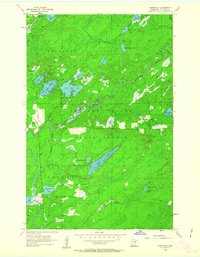
1956 Map of Whiteface
USGS Topo · Published 1963About this map
The Duluth Winnipeg and Pacific railroad cuts a north-south path through this pocket of St. Louis County, providing the primary industrial link through a landscape dominated by timber and water. Centered on the Cloquet Valley State Forest, the terrain is defined by a complex drainage network where the Whiteface River meanders toward the small settlement of Whiteface. This mid-century survey reveals a transition from the structured township lines of Ellsburg and Cotton to the dense glacial lakes and wetlands of the north woods. Significant water bodies like Long Lake, East Bass Lake, and the series of three Washusk Lakes illustrate the region's hydrography before modern development, while smaller features such as Moonshine Creek and Bug Lake indicate the localized naming conventions of the era's woodsmen and surveyors.
Find a feature on this map
28 named features on this map. Tap any name to fly to it.
Don’t see what you’re looking for? This feature index may not catch every label — zoom into the map to look around manually.
Map Details
Editions of this 1956 Whiteface Map
2 editions found
Other maps of this area

1951 · Central Lakes
USGS Topo · 1:24,000

1951 · Makinen
USGS Topo · 1:24,000

1953 · Canyon
USGS Topo · 1:24,000

1953 · Shaw
USGS Topo · 1:24,000

1953 · Boulder Lake Reservoir
USGS Topo · 1:24,000

1954 · Hibbing
USGS Topo · 1:250,000

1956 · Cotton
USGS Topo · 1:24,000

1956 · Whiteface
USGS Topo · 1:24,000

1957 · Hibbing
USGS Topo · 1:250,000

1957 · Markham
USGS Topo · 1:62,500