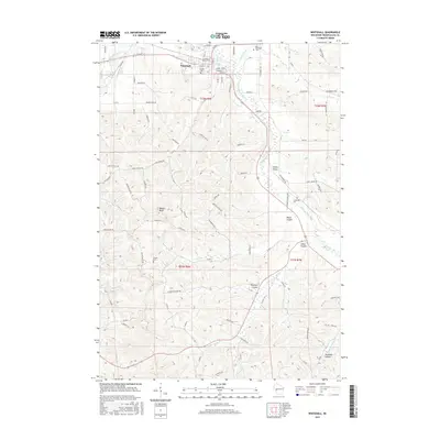
2015 Map of Whitehall
USGS Topo · Published 2015About this map
Whitehall serves as the focal point of this Trempealeau County landscape, situated at the confluence of several prominent coulees and the Trempealeau River. The map illustrates a deeply etched topography where agricultural life is defined by these narrow valleys, such as Irvin Coulee and Larkin Valley, which cut through the high ridges. This drainage pattern is further reinforced by Pigeon Creek and Fly Cr, creating a network of natural corridors that influenced the placement of original homesteads and cemeteries. Genealogists will find the locations of several burial grounds preserved, including Lincoln Cem and Old Whitehall Cem near the town center, as well as the more remote Tinnes Cem and Carpenter Cem. The terrain is punctuated by distinctive landmarks like Square Bluff, showing how the early road network, including Co Rd Q and Co Rd S, was forced to follow the winding contours of the land.
Find a feature on this map
87 named features on this map. Tap any name to fly to it.
Don’t see what you’re looking for? This feature index may not catch every label — zoom into the map to look around manually.
Map Details
Editions of this 2015 Whitehall Map
This is the sole edition of this map. No revisions or reprints were ever made.
Other maps of this area

1926 · North Bend
USGS Topo · 1:62,500

1926 · Whitehall
USGS Topo · 1:62,500

1927 · Blair
USGS Topo · 1:62,500

1929 · Whitehall
USGS Topo · 1:62,500

1929 · Galesville
USGS Topo · 1:62,500

1929 · North Bend
USGS Topo · 1:62,500

1953 · Eau Claire
USGS Topo · 1:250,000

1958 · Eau Claire
USGS Topo · 1:250,000

1964 · Eau Claire
USGS Topo · 1:250,000
1968 · Blair
USGS Topo · 1:62,500