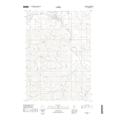
2018 Map of Whitehall
USGS Topo · Published 2018About this map
The Trempealeau River and its major tributary, Pigeon Creek, define the topography of this Trempealeau County region in 2018. The city of Whitehall sits at the confluence of these waterways, serving as a hub for the surrounding agricultural coulees. Further downstream to the southeast, the village of Blair occupies a bend in the river, showing the persistent relationship between these settlements and the valley floor. The map records several legacy burial grounds that offer significant value for genealogical research, including Lincoln Cem and Old Whitehall Cem near the county seat, as well as Carpenter Cem and Tinnes Cem situated in the more rural township areas.
Find a feature on this map
91 named features on this map. Tap any name to fly to it.
Don’t see what you’re looking for? This feature index may not catch every label — zoom into the map to look around manually.
Map Details
Editions of this 2018 Whitehall Map
This is the sole edition of this map. No revisions or reprints were ever made.
Other maps of this area

1926 · North Bend
USGS Topo · 1:62,500

1926 · Whitehall
USGS Topo · 1:62,500

1927 · Blair
USGS Topo · 1:62,500

1929 · Whitehall
USGS Topo · 1:62,500

1929 · Galesville
USGS Topo · 1:62,500

1929 · North Bend
USGS Topo · 1:62,500

1953 · Eau Claire
USGS Topo · 1:250,000

1958 · Eau Claire
USGS Topo · 1:250,000

1964 · Eau Claire
USGS Topo · 1:250,000
1968 · Blair
USGS Topo · 1:62,500