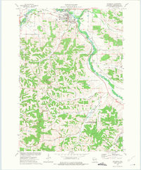
1973 Map of Whitehall
USGS Topo · Published 1975About this map
Whitehall sits at the junction of the Trempealeau River and Pigeon Creek, serving as a central hub for the surrounding Trempealeau County agricultural landscape in the 1970s. The Green Bay and Western railroad corridor dictates the path of commerce through the valley, passing by the County Hospital and local industrial landmarks like the Water Tank and Radio Tower.
Find a feature on this map
37 named features on this map. Tap any name to fly to it.
Don’t see what you’re looking for? This feature index may not catch every label — zoom into the map to look around manually.
Map Details
Editions of this 1973 Whitehall Map
This is the sole edition of this map. No revisions or reprints were ever made.
Other maps of this area

1926 · North Bend
USGS Topo · 1:62,500

1926 · Whitehall
USGS Topo · 1:62,500

1927 · Blair
USGS Topo · 1:62,500

1929 · Whitehall
USGS Topo · 1:62,500

1929 · Galesville
USGS Topo · 1:62,500

1929 · North Bend
USGS Topo · 1:62,500

1953 · Eau Claire
USGS Topo · 1:250,000

1958 · Eau Claire
USGS Topo · 1:250,000

1964 · Eau Claire
USGS Topo · 1:250,000
1968 · Blair
USGS Topo · 1:62,500