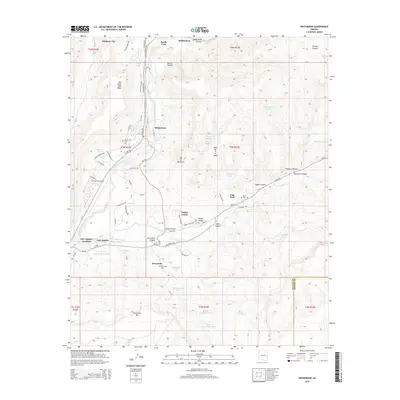
2014 Map of Whiteriver
USGS Topo · Published 2014About this map
Whiteriver and its surrounding communities sit at the confluence of the North Fork White River and E Fork White River, serving as a central hub for the Fort Apache Indian Reservation. The landscape is defined by dramatic geological features such as Nan Dahs Taan Mesa and the prominent Big A Mountain, with the settlement pattern following the river valleys and primary routes like Az-73. The map documents numerous tribal and community landmarks, including Whiteriver Cem, Sevenmile Cem, and the historic Fort Apache site. Further south, the terrain transitions into the high country of the Sevenmile Rim. This area’s infrastructure is geared toward local administration and residency, evidenced by the clustered residential streets of Rainbow City and the presence of the Whiteriver Airport. Numerous water management features like Agency Tank and Fort Apache Tank indicate the vital importance of water resources in this high-desert environment.
Find a feature on this map
90 named features on this map. Tap any name to fly to it.
Don’t see what you’re looking for? This feature index may not catch every label — zoom into the map to look around manually.
Map Details
Editions of this 2014 Whiteriver Map
This is the sole edition of this map. No revisions or reprints were ever made.
Other maps of this area

1954 · Clifton
USGS Topo · 1:250,000

1954 · Mesa
USGS Topo · 1:250,000

1957 · Mesa
USGS Topo · 1:250,000

1957 · Clifton
USGS Topo · 1:250,000

1958 · Clifton
USGS Topo · 1:250,000

1958 · Mesa
USGS Topo · 1:250,000

1960 · Mesa
USGS Topo · 1:250,000

1962 · Clifton
USGS Topo · 1:250,000

1964 · Mesa
USGS Topo · 1:250,000
1966 · Round Top Mtn
USGS Topo · 1:24,000