1978 Map of Whiteriver
USGS Topo · Published 1978About this map
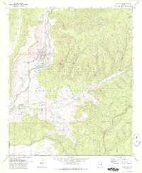
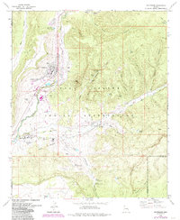
Fort Apache stands as a focal point in the southern portion of this landscape, situated near the confluence where the North Fork White River and East Fork White River meet. This 1970s revision by the Bureau of Indian Affairs details the infrastructure of the Fort Apache Indian Reservation, documenting educational and social centers like the Theodore Roosevelt Indian Sch and the East Fork Mission Sch. The settlement of Whiteriver is shown with its residential grid, Radio Facility, and proximity to Alchesay HS.
Find a feature on this map
64 named features on this map. Tap any name to fly to it.
Don’t see what you’re looking for? This feature index may not catch every label — zoom into the map to look around manually.
Map Details
Editions of this 1978 Whiteriver Map
2 editions found
Other maps of this area

1954 · Clifton
USGS Topo · 1:250,000

1954 · Mesa
USGS Topo · 1:250,000

1957 · Mesa
USGS Topo · 1:250,000

1957 · Clifton
USGS Topo · 1:250,000

1958 · Clifton
USGS Topo · 1:250,000

1958 · Mesa
USGS Topo · 1:250,000

1960 · Mesa
USGS Topo · 1:250,000

1962 · Clifton
USGS Topo · 1:250,000

1964 · Mesa
USGS Topo · 1:250,000
1966 · Round Top Mtn
USGS Topo · 1:24,000