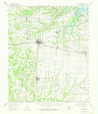
1958 Map of Whitesboro
USGS Topo · Published 1974About this map
The Lake Texoma shoreline at the Big Mineral Arm anchors the northeast corner of this North Texas survey, where the Hagerman National Wildlife Refuge provides a transition between the water and the rolling plains. The landscape is defined by the intersection of the Missouri Kansas and Texas and Texas and Pacific railroads, which shaped the development of towns like Whitesboro and Collinsville. Beyond the town centers, the map reveals a dense network of family and community landmarks, including Bones Chapel, Violott Ch, and Akers Cem. Petroleum extraction is a dominant industrial force across the quadrangle, evidenced by the extensive Whitesboro Oil Field, Dawkins Oil Field, and Woodbine Oil Field, which are interspersed among the headwaters of Mustang Creek and Beaver Creek.
Find a feature on this map
58 named features on this map. Tap any name to fly to it.
Don’t see what you’re looking for? This feature index may not catch every label — zoom into the map to look around manually.
Map Details
Editions of this 1958 Whitesboro Map
3 editions found
Other maps of this area

1901 · Denison
USGS Topo · 1:125,000

1902 · Gainesville
USGS Topo · 1:125,000

1943 · Gainesville
USGS Topo · 1:125,000

1954 · Sherman
USGS Topo · 1:250,000

1958 · Dorchester
USGS Topo · 1:24,000

1958 · Gordonville
USGS Topo · 1:62,500

1958 · Denison Dam
USGS Topo · 1:62,500

1958 · Sherman NW
USGS Topo · 1:24,000

1958 · Whitesboro
USGS Topo · 1:62,500

1958 · Sherman
USGS Topo · 1:250,000