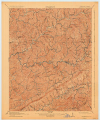
1915 Map of Whitesburg
USGS Topo · Published 1925About this map
Whitesburg serves as the focal point for this 1915 survey of the Kentucky coalfields, situated at the confluence of the Kentucky River and Cowan Creek. The map documents a rugged landscape defined by the prominent ridge of Pine Mountain, which marks the southeastern boundary between Letcher and Wise counties. Transportation during this era is anchored by the Lexington North railroad corridor, which follows the winding river valley to connect several small settlements such as Blackey and Sergent.
Find a feature on this map
114 named features on this map. Tap any name to fly to it.
Don’t see what you’re looking for? This feature index may not catch every label — zoom into the map to look around manually.
Map Details
Editions of this 1915 Whitesburg Map
4 editions found

Other maps of this area

1887 · Jonesville
USGS Topo · 1:125,000

1890 · Whitesburg
USGS Topo · 1:125,000

1891 · Hazard
USGS Topo · 1:125,000

1891 · Jonesville
USGS Topo · 1:125,000

1892 · Whitesburg
USGS Topo · 1:125,000

1894 · Estillville
USGS Topo · 1:125,000

1912 · Pound
USGS Topo · 1:48,000

1912 · Hindman
USGS Topo · 1:48,000

1913 · Oven Fork
USGS Topo · 1:48,000

1914 · Pound
USGS Topo · 1:62,500