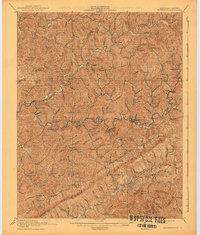
1915 Map of Whitesburg
USGS Topo · Published 1941About this map
Whitesburg serves as the central hub of this 1915 survey, situated at the confluence of several mountain valleys where the Lexington & Eastern RR and the Louisville & Nashville RR meet. The terrain is defined by the sharp ridges of Pine Mountain and the Cumberland Mountains to the south, which form the Kentucky Virginia boundary. Settlement patterns follow the narrow bottomlands of the North Fork and Carr Fork, marked by numerous numbered schools such as School No 1 and School No 5 that served the dispersed communities of Blackey, Thornton, and Jeremiah. The map documents a landscape on the verge of significant industrial change, with the railroads recently penetrating the coalfields. Local landmarks like Camp Branch Chapel and Indian Bottom are recorded alongside smaller settlements like Maxpatch and Colson, providing a detailed view of eastern Kentucky's social and physical geography during the early twentieth century.
Find a feature on this map
93 named features on this map. Tap any name to fly to it.
Don’t see what you’re looking for? This feature index may not catch every label — zoom into the map to look around manually.
Map Details
Editions of this 1915 Whitesburg Map
4 editions found

Other maps of this area

1887 · Jonesville
USGS Topo · 1:125,000

1890 · Whitesburg
USGS Topo · 1:125,000

1891 · Hazard
USGS Topo · 1:125,000

1891 · Jonesville
USGS Topo · 1:125,000

1892 · Whitesburg
USGS Topo · 1:125,000

1894 · Estillville
USGS Topo · 1:125,000

1912 · Pound
USGS Topo · 1:48,000

1912 · Hindman
USGS Topo · 1:48,000

1913 · Oven Fork
USGS Topo · 1:48,000

1914 · Pound
USGS Topo · 1:62,500