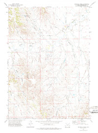
1971 Map of Whitetail Creek
USGS Topo · Published 1974About this map
Dillinger Ranch sits at the heart of this Wyoming landscape, where the energy industry and cattle ranching converged in the early 1970s. The map illustrates a complex network of resource extraction, with numerous sites marked as Drill Hole and Oil Well across the Bishop Ranch Oil Field and adjacent petroleum leases. This industrial activity is superimposed on a rugged drainage system defined by the Belle Fourche River and its various tributaries, including Whitetail Creek and Yellow Hammer Creek. The terrain is punctuated by distinctive landforms such as the Yellow Hammer Buttes and Cabin Canyon, while infrastructure like Bishop Road and various routes labeled Jeep Trail provide the only access through these breaks. Water management is evident at the Cabin Canyon Reservoir, a critical feature for both livestock and the surrounding Oil Field operations during this era.
Find a feature on this map
15 named features on this map. Tap any name to fly to it.
Don’t see what you’re looking for? This feature index may not catch every label — zoom into the map to look around manually.
Map Details
Editions of this 1971 Whitetail Creek Map
2 editions found
Other maps of this area

1954 · Gillette
USGS Topo · 1:250,000

1955 · Newcastle
USGS Topo · 1:250,000

1955 · Gillette
USGS Topo · 1:250,000

1958 · Gillette
USGS Topo · 1:250,000

1958 · Newcastle
USGS Topo · 1:250,000

1962 · Gillette
USGS Topo · 1:250,000

1971 · Coyote Draw
USGS Topo · 1:24,000

1971 · Coon Track Creek
USGS Topo · 1:24,000

1971 · Whitetail Creek
USGS Topo · 1:24,000

1971 · Rough Creek
USGS Topo · 1:24,000