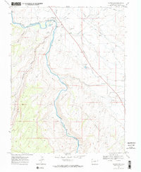
1969 Map of Whitewater
USGS Topo · Published 1972About this map
The Denver and Rio Grande Western River corridor serves as the primary artery for transport and industry in this Colorado landscape, passing through the settlement of Whitewater. The map documents a complex water management system vital to the arid environment, including the Kannah Creek (Aqueduct), Shropshire Ditch, and Extension Ditch. These man-made features contrast with the deeply eroded natural topography of Unaweep Canyon and Bangs Canyon. Local landmarks such as the Whitewater Cem and the Radio Towers (KREX) near the Desert Reservoir provide specific points of reference for genealogists and local historians. To the south, the terrain rises toward Mulbern Bench and the expansive area known as The Hunting Ground, reflecting the region's ranching and recreation character in the late 1960s.
Find a feature on this map
38 named features on this map. Tap any name to fly to it.
Don’t see what you’re looking for? This feature index may not catch every label — zoom into the map to look around manually.
Map Details
Editions of this 1969 Whitewater Map
3 editions found
Other maps of this area

1956 · Moab
USGS Topo · 1:250,000

1956 · Grand Junction
USGS Topo · 1:250,000

1959 · Grand Junction
USGS Topo · 1:250,000

1959 · Moab
USGS Topo · 1:250,000

1960 · Moab
USGS Topo · 1:250,000

1960 · Grand Junction
USGS Topo · 1:250,000

1962 · Moab
USGS Topo · 1:250,000

1962 · Grand Junction
USGS Topo · 1:250,000

1962 · Clifton
USGS Topo · 1:24,000

1962 · Grand Junction
USGS Topo · 1:24,000