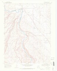
1969 Map of Whitewater
USGS Topo · Published 1972About this map
The Gunnison River and the Denver and Rio Grande Western railroad tracks define the north-south axis of this Western Slope landscape. Settlement is concentrated near Whitewater, where the Whitewater Cem and various Gravel Pits suggest a community built on industrial transit and local services. The complex water management system of the high desert is visible through the Kannah Creek (Aqueduct), the Tabequache Flow Line, and several irrigation ditches like the Extension Ditch serving Mulbern Bench. To the south, the terrain becomes more isolated as it moves into the Hunting Ground and the Hallock Basin, eventually reaching the stop at Deer Run. These features illustrate the late 1960s reliance on gravity-fed water systems and rail infrastructure to sustain agriculture and mining in Mesa County's arid river valleys.
Find a feature on this map
33 named features on this map. Tap any name to fly to it.
Don’t see what you’re looking for? This feature index may not catch every label — zoom into the map to look around manually.
Map Details
Editions of this 1969 Whitewater Map
3 editions found
Other maps of this area

1956 · Moab
USGS Topo · 1:250,000

1956 · Grand Junction
USGS Topo · 1:250,000

1959 · Grand Junction
USGS Topo · 1:250,000

1959 · Moab
USGS Topo · 1:250,000

1960 · Moab
USGS Topo · 1:250,000

1960 · Grand Junction
USGS Topo · 1:250,000

1962 · Moab
USGS Topo · 1:250,000

1962 · Grand Junction
USGS Topo · 1:250,000

1962 · Clifton
USGS Topo · 1:24,000

1962 · Grand Junction
USGS Topo · 1:24,000