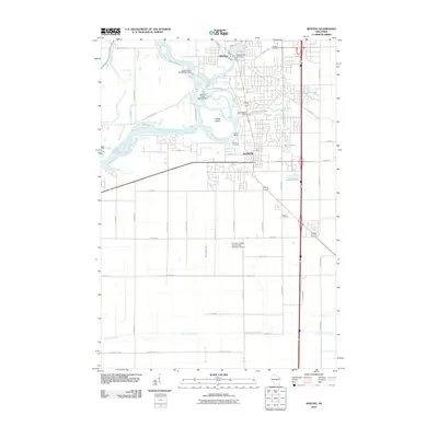
2010 Map of Whiting
USGS Topo · Published 2010About this map
The Wisconsin River and Plover River converge at the heart of this landscape, defining the industrial and civic development of Whiting and Plover. Hydropower and milling legacy are visible through specific structures like the Upper Paper Mill WP235 Dam and the Whiting Plover 2WP843 Dam. These waterways wrap around Fields Island and the landmark Yellow Banks, creating a complex riparian environment that once fueled the region’s early paper and lumber economy.
Find a feature on this map
58 named features on this map. Tap any name to fly to it.
Don’t see what you’re looking for? This feature index may not catch every label — zoom into the map to look around manually.
Map Details
Editions of this 2010 Whiting Map
This is the sole edition of this map. No revisions or reprints were ever made.
Other maps of this area

1955 · Rosholt
USGS Topo · 1:48,000

1955 · Green Bay
USGS Topo · 1:250,000

1956 · Stevens Point
USGS Topo · 1:48,000

1957 · Amherst
USGS Topo · 1:48,000

1957 · Whiting
USGS Topo · 1:48,000

1969 · Arnott
USGS Topo · 1:24,000
1969 · Almond
USGS Topo · 1:24,000
1969 · Polonia
USGS Topo · 1:24,000

1970 · Kellner
USGS Topo · 1:24,000

1970 · Stevens Point
USGS Topo · 1:24,000