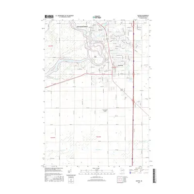
2015 Map of Whiting
USGS Topo · Published 2015About this map
The Wisconsin River carves a complex path through this central Wisconsin landscape, defining the western boundaries of Stevens Point and Whiting. This area is characterized by a dense network of water bodies, including the Plover River and its various impoundments like McDill Pond and Springville Pond. The confluence of these waterways created unique landforms such as Fields Island, which sits at the heart of the river's winding channels. South of the suburban expansion of Plover, the terrain shifts toward a highly organized agricultural grid, marked by an extensive drainage system including Ditch Number One and Ditch Number Two. Local history is preserved in several burial grounds like McDill Cem and Maine Cem, while the industrial and transportation footprint is noted by the Runway Leasing Inc Number 2 Airport.
Find a feature on this map
140 named features on this map. Tap any name to fly to it.
Don’t see what you’re looking for? This feature index may not catch every label — zoom into the map to look around manually.
Map Details
Editions of this 2015 Whiting Map
This is the sole edition of this map. No revisions or reprints were ever made.
Other maps of this area

1955 · Rosholt
USGS Topo · 1:48,000

1955 · Green Bay
USGS Topo · 1:250,000

1956 · Stevens Point
USGS Topo · 1:48,000

1957 · Amherst
USGS Topo · 1:48,000

1957 · Whiting
USGS Topo · 1:48,000

1969 · Arnott
USGS Topo · 1:24,000
1969 · Almond
USGS Topo · 1:24,000
1969 · Polonia
USGS Topo · 1:24,000

1970 · Kellner
USGS Topo · 1:24,000

1970 · Stevens Point
USGS Topo · 1:24,000