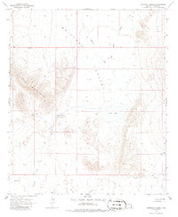
1966 Map of Whitlock Cienega
USGS Topo · Published 1986About this map
Whitlock Cienega serves as a focal point in this high desert landscape, located near the Old Stage Station along the eastern edge of the Whitlock Mountains. The geography of the mid-1960s is defined by its water sources, with the broad Whitlock Valley drained by Whitlock Wash and Hot Well Draw. These drainage patterns and intermittent water features like Parks Lake and Hidden Tank were essential for the cattle operations that characterized the region, such as the Delong Ranch found in the southeast corner. The presence of numerous wells, including West Well and Clay Well, underscores the reliance on groundwater for sustaining life and livestock in this arid Arizona corridor. The transition from the steep mountain slopes to the level expanse of Hospital Flat illustrates the typical basin and range topography of the area.
Find a feature on this map
15 named features on this map. Tap any name to fly to it.
Don’t see what you’re looking for? This feature index may not catch every label — zoom into the map to look around manually.
Map Details
Editions of this 1966 Whitlock Cienega Map
2 editions found
Other maps of this area

1917 · San Simon
USGS Topo · 1:125,000

1926 · Orange Butte
USGS Topo · 1:62,500

1928 · Bowie
USGS Topo · 1:62,500

1949 · Bowie
USGS Topo · 1:62,500

1950 · San Simon
USGS Topo · 1:62,500

1950 · Bowie
USGS Topo · 1:62,500

1951 · San Simon
USGS Topo · 1:62,500

1954 · Silver City
USGS Topo · 1:250,000

1958 · Silver City
USGS Topo · 1:250,000

1960 · Duncan
USGS Topo · 1:62,500