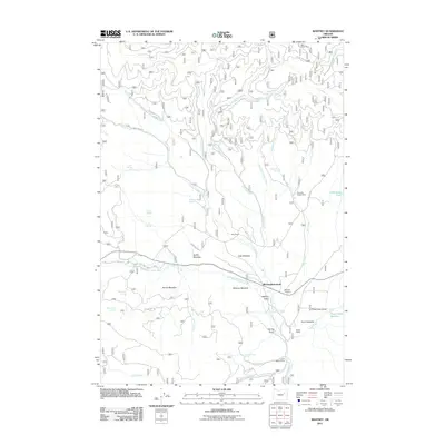
2011 Map of Whitney
USGS Topo · Published 2011About this map
The Whitney(historical) townsite sits at the heart of this Baker County landscape, centered near the confluence of the North Fork Burnt River and Camp Creek. This early 21st-century record documents the area's transition from a once-busy railroad town to a landscape of ranching and recreation. Evidence of its past remains in the Whitney Cemetery and nearby Whitney Meadow, while the surrounding terrain is marked by family-named landmarks like Walker Ranch, Hale Ranch, and Clifford.
Find a feature on this map
48 named features on this map. Tap any name to fly to it.
Don’t see what you’re looking for? This feature index may not catch every label — zoom into the map to look around manually.
Map Details
Editions of this 2011 Whitney Map
This is the sole edition of this map. No revisions or reprints were ever made.
Other maps of this area

1901 · Sumpter
USGS Topo · 1:125,000

1955 · Canyon City
USGS Topo · 1:250,000

1959 · Canyon City
USGS Topo · 1:250,000

1961 · Whitney
USGS Topo · 1:24,000

1972 · Austin
USGS Topo · 1:24,000

1972 · Mt. Ireland
USGS Topo · 1:24,000
1972 · Bourne
USGS Topo · 1:24,000
1972 · Granite
USGS Topo · 1:24,000
1972 · Sumpter
USGS Topo · 1:24,000

1972 · Greenhorn
USGS Topo · 1:24,000