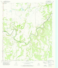
1973 Map of Whon
USGS Topo · Published 1976About this map
The Colorado River carves a deep, winding path through this central Texas landscape, marking the boundary between Coleman Co and McCulloch Co. This 1970s survey captures a transition point in rural infrastructure, where historical river access points like Mitchell Crossing, Knight Crossing, and Military Crossing remain prominent features of the local geography. The settlement of Whon and its associated Whon Cem serve as the primary community anchor in the northern portion of the sheet, complemented by Rockwood to the northwest. The terrain is defined by significant elevations such as Parks Mountain and Round Mountain, while the drainage network including Old Boggy Creek and Cow Creek illustrates the rugged hydrological patterns characteristic of the Edwards Plateau periphery. A modern Landing Strip and Roadside Park reflect the era's evolving transportation needs alongside established rural sites like Fife Cem.
Find a feature on this map
21 named features on this map. Tap any name to fly to it.
Don’t see what you’re looking for? This feature index may not catch every label — zoom into the map to look around manually.
Map Details
Editions of this 1973 Whon Map
2 editions found
Other maps of this area

1887 · Coleman
USGS Topo · 1:125,000

1889 · Coleman
USGS Topo · 1:125,000

1894 · Brady
USGS Topo · 1:125,000

1924 · Brady 2-a
USGS Topo · 1:48,000

1925 · Brady 2-b
USGS Topo · 1:48,000

1925 · Brady 1-b
USGS Topo · 1:48,000

1928 · Mercury
USGS Topo · 1:62,500

1928 · Waldrip
USGS Topo · 1:62,500

1950 · Mercury
USGS Topo · 1:62,500

1954 · Brownwood
USGS Topo · 1:250,000