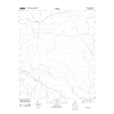
2012 Map of Whynot
USGS Topo · Published 2012About this map
The borderlands of Lauderdale County, Mississippi, and Choctaw County, Alabama, are defined by a complex network of creeks such as Little Alamuchee Cr and Yantley Cr. This 2012 survey illustrates the dispersed rural character of the area around the settlements of Alamucha and Whynot. The landscape is dotted with several small burial grounds, including McMurry Cem, Antioch Cem, and Coody Cemetery, which serve as primary anchors for local family histories. A notable modern landmark, the Whynot Raceway, sits near the junction of Alamucha Whynot Rd and Old Highway 19 SE. The creek systems here, including Kinterbish Cr and Tuckabum Cr, create a topography of winding country roads such as Silk Stocking Ln and E Old Wire Rd, tracing a transition from upland woods to the drainage basins of the Alabama-Mississippi state line.
Find a feature on this map
58 named features on this map. Tap any name to fly to it.
Don’t see what you’re looking for? This feature index may not catch every label — zoom into the map to look around manually.
Map Details
Editions of this 2012 Whynot Map
This is the sole edition of this map. No revisions or reprints were ever made.
Other maps of this area

1921 · Meridian
USGS Topo · 1:48,000

1923 · Meridian
USGS Topo · 1:62,500

1953 · Meridian
USGS Topo · 1:250,000

1957 · Meridian
USGS Topo · 1:250,000

1957 · Quitman
USGS Topo · 1:62,500

1965 · Meridian
USGS Topo · 1:250,000

1971 · Vimville
USGS Topo · 1:24,000
1971 · Toomsuba
USGS Topo · 1:24,000

1974 · Yantley
USGS Topo · 1:24,000

1974 · Ward
USGS Topo · 1:24,000