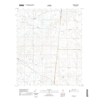
2020 Map of Whynot
USGS Topo · Published 2020About this map
The settlement of Alamucha sits at the northern edge of this landscape, where the border of Mississippi and Alabama carves through a dense network of creek drainages. To the southwest, the community of Whynot marks a crossroads along Old Hwy 19 SE. This borderland is defined by its numerous family and community burial grounds, including McMurry Cem, Antioch Cem, and Coody Cemetery, which are often located near the winding courses of Alamuchee Cr and Kinterbish Cr. The road network is heavily influenced by the drainage patterns of Hurricane Cr and Yantley Cr, with several local routes like Sam Culpepper Rd and Liberty Church Rd connecting the scattered homesteads. The terrain transitions across the state line into Choctaw and Sumter Counties, Alabama, following the flow of Little Cr and Woods Cr toward the east.
Find a feature on this map
60 named features on this map. Tap any name to fly to it.
Don’t see what you’re looking for? This feature index may not catch every label — zoom into the map to look around manually.
Map Details
Editions of this 2020 Whynot Map
This is the sole edition of this map. No revisions or reprints were ever made.
Other maps of this area

1921 · Meridian
USGS Topo · 1:48,000

1923 · Meridian
USGS Topo · 1:62,500

1953 · Meridian
USGS Topo · 1:250,000

1957 · Meridian
USGS Topo · 1:250,000

1957 · Quitman
USGS Topo · 1:62,500

1965 · Meridian
USGS Topo · 1:250,000

1971 · Vimville
USGS Topo · 1:24,000
1971 · Toomsuba
USGS Topo · 1:24,000

1974 · Yantley
USGS Topo · 1:24,000

1974 · Ward
USGS Topo · 1:24,000