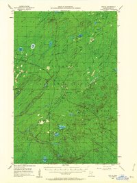
1953 Map of Whyte
USGS Topo · Published 1962About this map
Reserve Mining Company Railroad and the Duluth Missabe and Iron Range Railroad define the industrial character of this Lake County landscape during the early 1950s. The region is marked by numerous rail intersections and small settlements, including Whyte, Greenwood Junction, and Darby Junction, which served the extraction and transport needs of the Minnesota iron range. The topography is dominated by the vast Superior National Forest, featuring prominent elevations like Mt Weber and its nearby Lookout Tower.
Find a feature on this map
46 named features on this map. Tap any name to fly to it.
Don’t see what you’re looking for? This feature index may not catch every label — zoom into the map to look around manually.
Map Details
Editions of this 1953 Whyte Map
3 editions found
Other maps of this area

1952 · Babbitt SE
USGS Topo · 1:24,000

1953 · Whyte
USGS Topo · 1:62,500

1954 · Greenwood Lake
USGS Topo · 1:62,500

1954 · Silver Bay
USGS Topo · 1:62,500

1954 · Two Harbors
USGS Topo · 1:250,000

1955 · Isabella
USGS Topo · 1:62,500

1956 · Split Rock Point
USGS Topo · 1:24,000

1956 · King Lake
USGS Topo · 1:24,000

1956 · Split Rock Point
USGS Topo · 1:62,500

1957 · Two Harbors
USGS Topo · 1:250,000