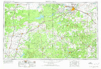
1954 Map of Wichita Falls
USGS Topo · Published 1974About this map
The Wichita Falls regional hub and its surrounding oil-producing plains are documented here during the mid-1950s. The landscape is defined by the convergence of major water management and extractive industry, seen in the extensive Oil Fields that dot the terrain between Seymour and Jacksboro. Large-scale water features like Lake Kemp and Lake Kickapoo indicate the importance of water storage in this semi-arid region of North Texas.
Find a feature on this map
168 named features on this map. Tap any name to fly to it.
Don’t see what you’re looking for? This feature index may not catch every label — zoom into the map to look around manually.
Map Details
Editions of this 1954 Wichita Falls Map
3 editions found

Other maps of this area

1890 · Breckenridge
USGS Topo · 1:125,000

1891 · Weatherford
USGS Topo · 1:125,000

1891 · Palo Pinto
USGS Topo · 1:125,000

1891 · Anson
USGS Topo · 1:125,000

1892 · Albany
USGS Topo · 1:125,000

1893 · Albany
USGS Topo · 1:125,000

1893 · Roby
USGS Topo · 1:125,000

1893 · Anson
USGS Topo · 1:125,000

1893 · Weatherford
USGS Topo · 1:125,000

1901 · Addington
USGS Topo · 1:125,000