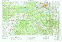
1954 Map of Wichita Falls
USGS Topo · Published 1976About this map
Wichita Falls anchors this mid-century survey of North Texas, where the transition from agricultural plains to an industrial energy economy is clearly visible. The landscape is heavily marked by extensive Oil Field symbols, stretching between settlements like Archer City, Seymour, and Throckmorton. Water management is a dominant feature, with large reservoirs such as Lake Kemp, Lake Kickapoo, and the newly created Lake Arrowhead providing essential resources for the region's growth.
Find a feature on this map
128 named features on this map. Tap any name to fly to it.
Don’t see what you’re looking for? This feature index may not catch every label — zoom into the map to look around manually.
Map Details
Editions of this 1954 Wichita Falls Map
3 editions found

Other maps of this area

1890 · Breckenridge
USGS Topo · 1:125,000

1891 · Weatherford
USGS Topo · 1:125,000

1891 · Palo Pinto
USGS Topo · 1:125,000

1891 · Anson
USGS Topo · 1:125,000

1892 · Albany
USGS Topo · 1:125,000

1893 · Albany
USGS Topo · 1:125,000

1893 · Roby
USGS Topo · 1:125,000

1893 · Anson
USGS Topo · 1:125,000

1893 · Weatherford
USGS Topo · 1:125,000

1901 · Addington
USGS Topo · 1:125,000