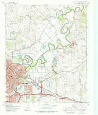
1972 Map of Wichita Falls East
USGS Topo · Published 1986About this map
Sheppard Air Force Base dominates the northern landscape, while the sprawling rail infrastructure of Wichita Falls defines the southern half of this 1970s study. The convergence of the Fort Worth and Denver RR, Missouri-Kansas-Texas RR, and Wichita Valley RR highlights the city's importance as a regional transportation hub. The Wichita River snakes through the center of the sheet, bordered by numerous gravel pits and public spaces like Williams Park and Spudder Park. Educational and civic development is evidenced by the presence of Booker T Washington Jr HS, Lamar Sch, and the County Farm. To the east, the terrain opens into rural landscape marked by the Kempner Cem and the small settlement of Raymond, offering a view of the transition from industrial city to North Texas ranch land.
Find a feature on this map
54 named features on this map. Tap any name to fly to it.
Don’t see what you’re looking for? This feature index may not catch every label — zoom into the map to look around manually.
Map Details
Editions of this 1972 Wichita Falls East Map
2 editions found
Other maps of this area

1915 · Burkburnett
USGS Topo · 1:24,000

1918 · Buckburnett
USGS Topo · 1:31,680

1954 · Wichita Falls
USGS Topo · 1:250,000

1955 · Lawton
USGS Topo · 1:250,000

1956 · Sloop Creek
USGS Topo · 1:24,000

1956 · Lake Wichita
USGS Topo · 1:24,000

1957 · Wichita Falls West
USGS Topo · 1:24,000

1957 · Burkburnett
USGS Topo · 1:62,500

1957 · Randlett
USGS Topo · 1:62,500

1957 · Wichita Falls East
USGS Topo · 1:62,500