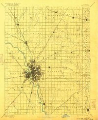
1894 Map of Wichita
USGS Topo · Published 1921About this map
The confluence of the Arkansas River and the Little Arkansas River serves as the focal point for the developing city of Wichita. This survey, conducted in the late 1880s, captures a pivotal era of infrastructure expansion as multiple rail lines converge on the central hub. Major routes including the Atchison Topeka and Santa Fe Railroad and the Missouri Pacific Railroad radiate through the surrounding townships, linking smaller settlements like Derby, Valley Center, and Andover. The grid-like patterns of the burgeoning city contrast with the winding paths of Chisholm Creek and Gypsum Creek, while outlying rural communities such as Rose Hill and Oatville appear as established agricultural centers. The map illustrates a landscape transitioning from open prairie to a tightly networked regional economy defined by its river valleys and steam-powered transportation corridors.
Find a feature on this map
79 named features on this map. Tap any name to fly to it.
Don’t see what you’re looking for? This feature index may not catch every label — zoom into the map to look around manually.
Map Details
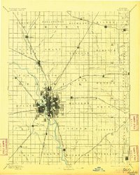
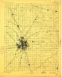
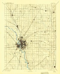
Editions of this 1894 Wichita Map
5 editions found

Other maps of this area

1888 · Eldorado
USGS Topo · 1:125,000

1889 · Newton
USGS Topo · 1:125,000

1889 · Burden
USGS Topo · 1:125,000

1889 · Cheney
USGS Topo · 1:125,000

1889 · Wichita
USGS Topo · 1:125,000

1889 · Caldwell
USGS Topo · 1:125,000

1890 · Wellington
USGS Topo · 1:125,000

1891 · Hutchinson
USGS Topo · 1:125,000

1891 · Cheney
USGS Topo · 1:125,000

1893 · Caldwell
USGS Topo · 1:125,000