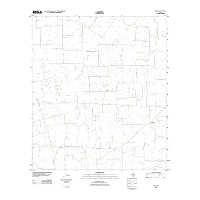
2010 Map of Wied
USGS Topo · Published 2010About this map
The unincorporated community of Wied serves as a central point in this rural Lavaca County landscape, situated at the intersection of local routes north of Mount Olive. The area is defined by its network of drainage systems, including the southward-flowing Smothers Creek, Boggy Creek, and Ponton Creek, which carve through the agricultural terrain. Small rural clusters like Worthing and Mont Mont are scattered across the quadrangle, connected by an extensive system of county roads and farm-to-market routes such as FM 1891 and FM 340. Genealogists and local historians can locate the Charlottenberg Cemetery Rd in the north, while aviation history is represented by the Dean Ranch Airport near the northwestern boundary. The map illustrates a Texas ranching and farming region where family-named landmarks like Louis Sitka persist alongside the natural course of Rocky Creek and Mustang Creek.
Find a feature on this map
66 named features on this map. Tap any name to fly to it.
Don’t see what you’re looking for? This feature index may not catch every label — zoom into the map to look around manually.
Map Details
Editions of this 2010 Wied Map
This is the sole edition of this map. No revisions or reprints were ever made.
Other maps of this area

1901 · Flatonia
USGS Topo · 1:125,000

1919 · Schulenburg
USGS Topo · 1:62,500

1953 · Seguin
USGS Topo · 1:250,000

1958 · Seguin
USGS Topo · 1:250,000

1962 · Hallettsville
USGS Topo · 1:24,000

1963 · Yoakum
USGS Topo · 1:24,000

1963 · Sweet Home
USGS Topo · 1:24,000

1964 · Ezzell
USGS Topo · 1:24,000

1965 · Wied
USGS Topo · 1:24,000

1965 · Komensky
USGS Topo · 1:24,000