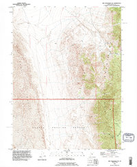
1993 Map of Wig Mtn NE
USGS Topo · Published 1996About this map
The Dugway Proving Ground military reservation dominates the southern expanse of this map, transitioning into the sprawling Sand Dunes and the Mud Flat to the west. This landscape is defined by the stark verticality of the Cedar Mountains, which run north to south through the center of the quadrangle. Sparse water sources like Browns Spring and Cedar Spring provide the only relief in this high desert environment. The topography is further marked by deep cuts such as Rydalch Canyon and Six Horse Pass Canyon, which carve through the mountain range. This 1993 revision, based on surveys dating back to the 1950s, details a network of 4wd tracks that provide the only terrestrial access through these remote geological formations. The map effectively illustrates the isolation of the Great Salt Lake Desert, where movement is constrained by the peaks and the vast, shifting sands of the western basin.
Find a feature on this map
12 named features on this map. Tap any name to fly to it.
Don’t see what you’re looking for? This feature index may not catch every label — zoom into the map to look around manually.
Map Details
Editions of this 1993 Wig Mtn NE Map
This is the sole edition of this map. No revisions or reprints were ever made.
Other maps of this area

1885 · Tooele Valley
USGS Topo · 1:250,000

1953 · Tooele
USGS Topo · 1:250,000

1954 · Wig Mtn SW
USGS Topo · 1:24,000

1954 · Wig Mtn NW
USGS Topo · 1:24,000

1955 · Tabbys Peak
USGS Topo · 1:24,000

1955 · Wig Mtn
USGS Topo · 1:24,000

1955 · Wig Mtn NE
USGS Topo · 1:24,000

1955 · Tabbys Peak SW
USGS Topo · 1:24,000

1955 · Tooele
USGS Topo · 1:250,000

1973 · Quincy Spring
USGS Topo · 1:24,000