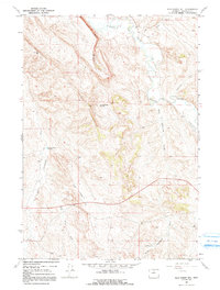
1967 Map of Wild Horse Hill
USGS Topo · Published 1991About this map
The Nowood River valley and its surrounding drainage systems define the geography of this Washakie County landscape in the late 1960s. The map highlights the vital role of water management in this arid region, as evidenced by the West Ditch and the Victoria Windsor Ditch snaking along the riverbanks to support local agriculture. The terrain rises sharply from the river bottom to prominent elevations like Blue Ridge and Wild Horse Hill, while a network of ephemeral watercourses including Little Cottonwood Creek, Wild Horse Creek, and Red Gulch carve into the high ground. Early industrial activity is visible in the presence of the Occidental Well (Flowing) and a Drill Hole, reflecting the region's history of mineral and water exploration. Livestock and ranching needs are further evidenced by the Big Cottonwood Reservoir, a critical water source located in the southwestern portion of the quadrangle.
Find a feature on this map
13 named features on this map. Tap any name to fly to it.
Don’t see what you’re looking for? This feature index may not catch every label — zoom into the map to look around manually.
Map Details
Editions of this 1967 Wild Horse Hill Map
2 editions found
Other maps of this area

1899 · Cloud peak
USGS Topo · 1:125,000

1901 · Cloud Peak
USGS Topo · 1:125,000

1955 · Sheridan
USGS Topo · 1:250,000

1955 · Arminto
USGS Topo · 1:250,000

1958 · Sheridan
USGS Topo · 1:250,000

1958 · Arminto
USGS Topo · 1:250,000

1962 · Sheridan
USGS Topo · 1:250,000

1962 · Arminto
USGS Topo · 1:250,000

1966 · Cabin Fork
USGS Topo · 1:24,000
1966 · Joe Emge Creek
USGS Topo · 1:24,000