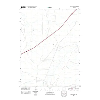
2012 Map of Wildcat Butte
USGS Topo · Published 2012About this map
Wildcat Butte rises as a prominent landmark in this high-desert landscape of Sweetwater County. The terrain is defined by a network of drainage features like Blumel Draw and isolated water sources including Meadow Springs and Carter Spring. Human presence is concentrated near Church Butte Camp, a small settlement cluster linked by Church Butte Rd. A major multi-lane highway bisects the region from the southwest to the northeast, slicing through the open rangeland and providing a modern contrast to the traditional pastoral infrastructure of cattle camps and springs. The map documents the persistent importance of named water points and topographical markers for navigation in an area characterized by wide-open spaces and sparse development.
Find a feature on this map
6 named features on this map. Tap any name to fly to it.
Don’t see what you’re looking for? This feature index may not catch every label — zoom into the map to look around manually.
Map Details
Editions of this 2012 Wildcat Butte Map
This is the sole edition of this map. No revisions or reprints were ever made.
Other maps of this area

1954 · Ogden
USGS Topo · 1:250,000

1954 · Rock Springs
USGS Topo · 1:250,000

1958 · Ogden
USGS Topo · 1:250,000

1958 · Rock Springs
USGS Topo · 1:250,000

1960 · Ogden
USGS Topo · 1:250,000

1961 · Granger
USGS Topo · 1:24,000

1962 · Rock Springs
USGS Topo · 1:250,000

1964 · Butcher Knife Draw
USGS Topo · 1:24,000

1964 · Antelope Knoll
USGS Topo · 1:24,000
1964 · Wildcat Butte
USGS Topo · 1:24,000