
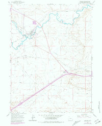
1961 Map of Granger
USGS Topo · Published 1964About this map
Blacks Fork and Hams Fork converge in this high-desert landscape, creating a vital corridor for westward migration and transportation in Sweetwater County. The settlement of Granger serves as a central hub where the Union Pacific railroad parallels the historic paths of the Emigrant Trail and Overland Trail. This intersection of routes highlights the area's long-standing role as a gateway across the Wyoming plains.
Find a feature on this map
15 named features on this map. Tap any name to fly to it.
Don’t see what you’re looking for? This feature index may not catch every label — zoom into the map to look around manually.
Map Details
Editions of this 1961 Granger Map
2 editions found
Other maps of this area

1954 · Ogden
USGS Topo · 1:250,000

1954 · Rock Springs
USGS Topo · 1:250,000

1958 · Ogden
USGS Topo · 1:250,000

1958 · Rock Springs
USGS Topo · 1:250,000

1960 · Ogden
USGS Topo · 1:250,000

1961 · Blue Point
USGS Topo · 1:24,000

1961 · Little America
USGS Topo · 1:24,000

1961 · Sevenmile Gulch
USGS Topo · 1:24,000

1962 · Rock Springs
USGS Topo · 1:250,000

1964 · Antelope Knoll NE
USGS Topo · 1:24,000