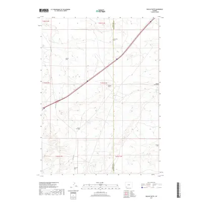
2017 Map of Wildcat Butte
USGS Topo · Published 2017About this map
Wildcat Butte rises as a prominent landmark in this high-desert landscape, where the border between Uinta County and Sweetwater County bisects the terrain. The map reveals an arid drainage network defined by various named features such as Caterpillar Draw, Blumel Draw, and the extensive Meadow Springs Wash. These erosional patterns indicate the significant role of intermittent water in shaping the topography, with permanent water sources like Meadow Springs and Carter Spring serving as vital points in an otherwise dry expanse. Human movement through this portion of Wyoming is primarily facilitated by the interstate corridor and Church Butte Rd, which provides access to the interior. The prevalence of named hollows and draws, including Porter Hollow and Jackknife Draw, underscores the importance of local naming conventions for navigating the repetitive landforms of the sagebrush steppe.
Find a feature on this map
17 named features on this map. Tap any name to fly to it.
Don’t see what you’re looking for? This feature index may not catch every label — zoom into the map to look around manually.
Map Details
Editions of this 2017 Wildcat Butte Map
This is the sole edition of this map. No revisions or reprints were ever made.
Other maps of this area

1954 · Ogden
USGS Topo · 1:250,000

1954 · Rock Springs
USGS Topo · 1:250,000

1958 · Ogden
USGS Topo · 1:250,000

1958 · Rock Springs
USGS Topo · 1:250,000

1960 · Ogden
USGS Topo · 1:250,000

1961 · Granger
USGS Topo · 1:24,000

1962 · Rock Springs
USGS Topo · 1:250,000

1964 · Butcher Knife Draw
USGS Topo · 1:24,000

1964 · Antelope Knoll
USGS Topo · 1:24,000
1964 · Wildcat Butte
USGS Topo · 1:24,000