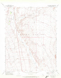
1969 Map of Wildcat Wash NW
USGS Topo · Published 1972About this map
Coyote Spring Valley dominates this 1969 topographic study, capturing a remote stretch of Lincoln County defined by its seasonal drainage systems and protected arid lands. The western edge of the map is bordered by the Desert National Wildlife Range, a massive conservation area established for the protection of desert bighorn sheep. Water, though scarce, is the primary shaper of the landscape here, evidenced by the confluence of Kane Springs Wash and Pahranagat Wash. These ephemeral watercourses create a distinct network across the valley floor, supporting the namesake Coyote Spring. Human activity is sparse, marked primarily by a Dry Well and several Jeep Trails that navigate the alluvial fans. Small industrial footprints like a Borrow Pit indicate localized material extraction in an otherwise undisturbed high-desert environment.
Find a feature on this map
10 named features on this map. Tap any name to fly to it.
Don’t see what you’re looking for? This feature index may not catch every label — zoom into the map to look around manually.
Map Details
Editions of this 1969 Wildcat Wash NW Map
2 editions found
Other maps of this area

1885 · Pioche
USGS Topo · 1:250,000

1886 · Saint Thomas
USGS Topo · 1:250,000

1886 · Pioche
USGS Topo · 1:250,000

1893 · Saint Thomas
USGS Topo · 1:250,000

1907 · Las Vegas
USGS Topo · 1:250,000

1908 · Las Vegas
USGS Topo · 1:250,000

1945 · Sheep Range
USGS Topo · 1:125,000

1945 · Alamo
USGS Topo · 1:125,000

1954 · Caliente
USGS Topo · 1:250,000

1954 · Las Vegas
USGS Topo · 1:250,000