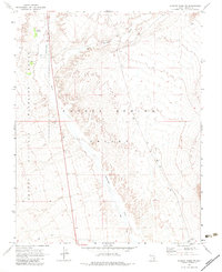
1969 Map of Wildcat Wash NW
USGS Topo · Published 1983About this map
Coyote Spring Valley dominates this 1960s landscape, illustrating a critical arid corridor in Lincoln County. The map details the drainage systems of Pahranagat Wash and Kane Springs Wash, which define the hydrologic character of this high desert region. Within the eastern boundary of the Desert National Wildlife Range, the terrain is marked by essential water sources like Coyote Spring and a Dry Well, indicating the precarious nature of water management for local wildlife and ranching interests during this era.
Find a feature on this map
14 named features on this map. Tap any name to fly to it.
Don’t see what you’re looking for? This feature index may not catch every label — zoom into the map to look around manually.
Map Details
Editions of this 1969 Wildcat Wash NW Map
2 editions found
Other maps of this area

1885 · Pioche
USGS Topo · 1:250,000

1886 · Saint Thomas
USGS Topo · 1:250,000

1886 · Pioche
USGS Topo · 1:250,000

1893 · Saint Thomas
USGS Topo · 1:250,000

1907 · Las Vegas
USGS Topo · 1:250,000

1908 · Las Vegas
USGS Topo · 1:250,000

1945 · Sheep Range
USGS Topo · 1:125,000

1945 · Alamo
USGS Topo · 1:125,000

1954 · Caliente
USGS Topo · 1:250,000

1954 · Las Vegas
USGS Topo · 1:250,000