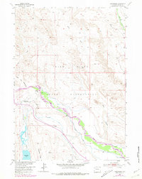
1952 Map of Wilderness
USGS Topo · Published 1979About this map
The Wind River Indian Reservation landscape is defined here by a complex network of water management infrastructure along the Wind River. This mid-century survey reveals the extent of the irrigation systems supporting the valley, including the Dinwoody Canal, Lannigans Ditch, and an aqueduct that traverse the terrain near Wilderness. The presence of a flume, a ford, and a gaging station illustrates the engineering required to harness the river's flow for agriculture in this high-elevation region.
Find a feature on this map
22 named features on this map. Tap any name to fly to it.
Don’t see what you’re looking for? This feature index may not catch every label — zoom into the map to look around manually.
Map Details
Editions of this 1952 Wilderness Map
4 editions found
Other maps of this area

1904 · Kirwin
USGS Topo · 1:125,000

1906 · Kirwin
USGS Topo · 1:125,000

1952 · Wilderness
USGS Topo · 1:24,000

1952 · Hays Park
USGS Topo · 1:24,000

1952 · Crowheart NW
USGS Topo · 1:24,000

1952 · Blue Holes
USGS Topo · 1:24,000

1952 · Crowheart
USGS Topo · 1:24,000

1952 · Burris
USGS Topo · 1:24,000

1955 · Thermopolis
USGS Topo · 1:250,000

1958 · Thermopolis
USGS Topo · 1:250,000