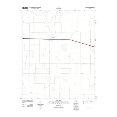
2010 Map of Wildorado
USGS Topo · Published 2010About this map
Wildorado serves as the central hub of this High Plains landscape, where the town's grid is bisected by a major east-west highway and bordered by an extensive network of county roads. The terrain is defined by a series of intermittent drainages, including Wildorado Creek, Daniels Creek, and Pedrosa Creek, which cut through the agricultural surroundings. A notable feature in the southern portion of the quadrangle is the Bynum Ranch, representing the region's enduring ranching heritage. To the east, Ida Lake provides a localized water feature amidst the expansive plains. The road system is particularly dense with labeled routes like Frying Pan Rd and W Farmers Ave, reflecting a landscape heavily partitioned for farming and livestock. In the southwest, the headwaters of North Palo Duro Creek begin their descent, marking the start of more significant topographical changes found further downstream.
Find a feature on this map
30 named features on this map. Tap any name to fly to it.
Don’t see what you’re looking for? This feature index may not catch every label — zoom into the map to look around manually.
Map Details
Editions of this 2010 Wildorado Map
This is the sole edition of this map. No revisions or reprints were ever made.
Other maps of this area

1934 · Ady
USGS Topo · 1:62,500

1936 · Ady
USGS Topo · 1:62,500

1954 · Tucumcari
USGS Topo · 1:250,000

1958 · Tucumcari
USGS Topo · 1:250,000

1962 · Wildorado
USGS Topo · 1:62,500

1965 · Everett
USGS Topo · 1:24,000

1965 · Allison Ranch
USGS Topo · 1:24,000

1966 · Jay Taylor Ranch
USGS Topo · 1:24,000
1966 · Wolf Mountain
USGS Topo · 1:24,000

1966 · Rotten Hill
USGS Topo · 1:24,000