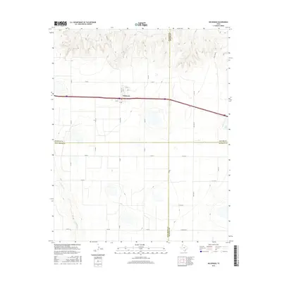
2016 Map of Wildorado
USGS Topo · Published 2016About this map
Wildorado occupies a strategic position on the High Plains where the borders of Oldham, Potter, Randall, and Deaf Smith counties converge. This 2016 survey highlights the community's grid, centered on Main St and Locust St, serving as a critical waypoint along the east-west interstate corridor. The surrounding landscape is defined by the headwaters of several drainage systems, including Wildorado Cr and Pedrosa Cr to the north, and the meandering course of N Palo Duro Cr to the southwest. To the east, Ida Lake sits near the junction of Westline Rd and the regional highway. The map reflects a classic Panhandle agricultural layout, with a dense network of section-line roads such as Co Rd 47 and Frying Pan Rd that facilitate movement through the open prairie and toward the breaks of the Palo Duro.
Find a feature on this map
35 named features on this map. Tap any name to fly to it.
Don’t see what you’re looking for? This feature index may not catch every label — zoom into the map to look around manually.
Map Details
Editions of this 2016 Wildorado Map
This is the sole edition of this map. No revisions or reprints were ever made.
Other maps of this area

1934 · Ady
USGS Topo · 1:62,500

1936 · Ady
USGS Topo · 1:62,500

1954 · Tucumcari
USGS Topo · 1:250,000

1958 · Tucumcari
USGS Topo · 1:250,000

1962 · Wildorado
USGS Topo · 1:62,500

1965 · Everett
USGS Topo · 1:24,000

1965 · Allison Ranch
USGS Topo · 1:24,000

1966 · Jay Taylor Ranch
USGS Topo · 1:24,000
1966 · Wolf Mountain
USGS Topo · 1:24,000

1966 · Rotten Hill
USGS Topo · 1:24,000