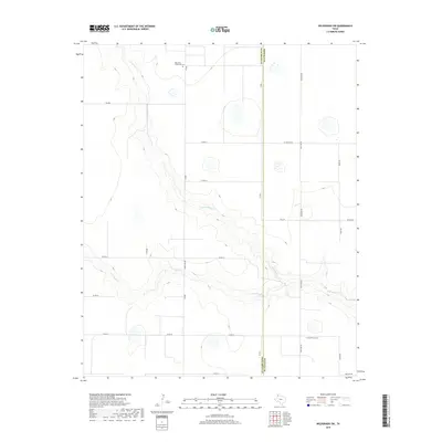
2019 Map of Wildorado SW
USGS Topo · Published 2019About this map
Palo Duro Wildorado Cem sits in the northern reaches of this High Plains landscape, serving as a localized point of historical interest in an area defined by the meandering path of Palo Duro Cr. The drainage system of N Palo Duro Cr cuts through the terrain, creating the primary relief in an otherwise grid-patterned agricultural and ranching district. This 2019 survey documents the precise boundary between Deaf Smith and Randall Counties, a line that bisects several local roads including Co Rd 18 and Co Rd 21. The map illustrates a modern rural infrastructure of farm-to-market roads and county lanes, such as FM 2219 and W Country Club Rd, which provide access to the expansive open spaces of the Panhandle.
Find a feature on this map
22 named features on this map. Tap any name to fly to it.
Don’t see what you’re looking for? This feature index may not catch every label — zoom into the map to look around manually.
Map Details
Editions of this 2019 Wildorado SW Map
This is the sole edition of this map. No revisions or reprints were ever made.
Other maps of this area

1954 · Tucumcari
USGS Topo · 1:250,000

1954 · Clovis
USGS Topo · 1:250,000

1958 · Clovis
USGS Topo · 1:250,000

1958 · Tucumcari
USGS Topo · 1:250,000

1961 · Buffalo Lake
USGS Topo · 1:62,500

1962 · Wildorado
USGS Topo · 1:62,500

1965 · Everett
USGS Topo · 1:24,000

1965 · Allison Ranch
USGS Topo · 1:24,000

1971 · Hereford NE
USGS Topo · 1:24,000
1984 · Bivins Lake
USGS Topo · 1:24,000