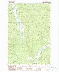
1986 Map of Wildwood
USGS Topo · Published 1986About this map
The South Fork Chehalis River carves a winding path through the western half of this 1980s landscape, defining the topography near the settlement of Wildwood. To the south, the community of Ryderwood sits near the boundary of Lewis and Cowlitz counties, surrounded by a complex network of drainage systems including Campbell Creek and Stillwater Creek. The area is characterized by industrial and logistical markers of the mid-20th century, such as an Old Railroad Grade that traces the base of Cougar Flat, and several Quarries and a Borrow Pit indicating local resource extraction. Prominent elevations like Snow Peak and Pumphrey Mtn overlook the numerous creek valleys, while smaller landmarks like Water Tanks and Sewage Disposal Ponds provide evidence of the rural infrastructure supporting these timber-country outposts during this era of Washington’s development.
Find a feature on this map
43 named features on this map. Tap any name to fly to it.
Don’t see what you’re looking for? This feature index may not catch every label — zoom into the map to look around manually.
Map Details
Editions of this 1986 Wildwood Map
This is the sole edition of this map. No revisions or reprints were ever made.
Other maps of this area

1916 · Chehalis
USGS Topo · 1:125,000

1941 · Meskill
USGS Topo · 1:62,500

1941 · Olequa
USGS Topo · 1:62,500

1953 · Hoquiam
USGS Topo · 1:250,000

1953 · Castle Rock
USGS Topo · 1:62,500

1953 · Ryderwood
USGS Topo · 1:62,500

1953 · Adna
USGS Topo · 1:62,500

1954 · Centralia
USGS Topo · 1:62,500

1957 · Hoquiam
USGS Topo · 1:250,000

1958 · Hoquiam
USGS Topo · 1:250,000