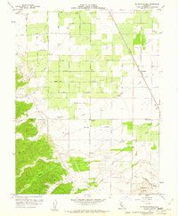
1959 Map of Wildwood School
USGS Topo · Published 1961About this map
The Wildwood School stands as a central landmark in this agricultural landscape where the Colusa Co Yolo Co line divides the northern orchards and fields from the rising terrain of the Dunnigan Hills. The settlement of Harrington marks a key point along the Southern Pacific railroad line, which runs diagonally through the valley. This 1959 survey reveals a highly organized grid of rural roads, including Marine Avenue, Grant Avenue, and Wisconsin Avenue, supporting the region's intensive farming. Water management is evident through the winding paths of Buckeye Creek and Petroleum Creek, while several landing strips indicate the importance of aerial access for these remote properties. To the south, the landscape shifts into more complex topography with numerous seasonal drainages like Wildcat Creek and Mushoak Creek carving through the hills.
Find a feature on this map
29 named features on this map. Tap any name to fly to it.
Don’t see what you’re looking for? This feature index may not catch every label — zoom into the map to look around manually.
Map Details
Editions of this 1959 Wildwood School Map
3 editions found
Other maps of this area

1888 · Marysville
USGS Topo · 1:125,000

1891 · Marysville
USGS Topo · 1:125,000

1894 · Marysville
USGS Topo · 1:125,000

1895 · Marysville
USGS Topo · 1:125,000

1905 · Harrington
USGS Topo · 1:24,000

1907 · Dunnigan
USGS Topo · 1:62,500

1907 · Colusa
USGS Topo · 1:62,500

1911 · Grimes
USGS Topo · 1:31,680

1916 · Harrington
USGS Topo · 1:31,680

1916 · Hershey
USGS Topo · 1:31,680