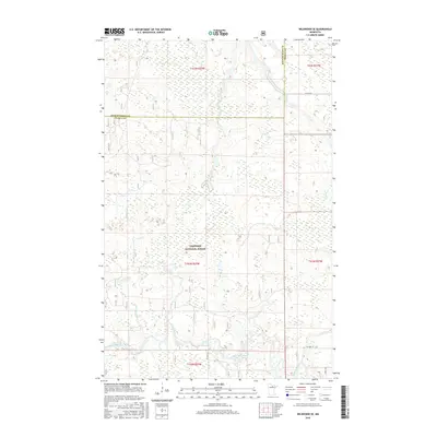
2016 Map of Wildwood SE
USGS Topo · Published 2016About this map
The Chippewa National Forest dominates this landscape in northern Minnesota, where the Big Fork River carves a winding path through the southern townships. The river's course is punctuated by Hauck Rapids, a notable hydrologic feature in an area defined by low-lying wetlands and creek systems like Plum Cr and Bowman Cr. This 2016 survey illustrates the remote character of the boundary between Koochiching and Itasca counties, showing a region largely dedicated to timber management and conservation rather than dense settlement. Surface transportation is limited to established routes such as Co Hwy 14 and Co Rd 259, providing essential access points for those navigating the forest and river corridor. The map serves as a precise record of the natural drainage patterns and forest boundaries within this North Woods environment.
Find a feature on this map
14 named features on this map. Tap any name to fly to it.
Don’t see what you’re looking for? This feature index may not catch every label — zoom into the map to look around manually.
Map Details
Editions of this 2016 Wildwood SE Map
This is the sole edition of this map. No revisions or reprints were ever made.
Other maps of this area

1918 · Zora
USGS Topo · 1:62,500

1919 · Zora
USGS Topo · 1:62,500

1919 · Marcell
USGS Topo · 1:62,500

1954 · Hibbing
USGS Topo · 1:250,000

1957 · Hibbing
USGS Topo · 1:250,000

1958 · Hibbing
USGS Topo · 1:250,000

1964 · Hibbing
USGS Topo · 1:250,000
1970 · Spring Lake
USGS Topo · 1:24,000
1970 · Bigfork
USGS Topo · 1:24,000
1970 · Wirt
USGS Topo · 1:24,000